Zompist, I suggest you keep as much of the original Ereláean and Arcelean climate as you can.
WRT Gurdago, it struck me that what we might call the Zëi Šure Čor might easily extend up to Ludyn. Could you explain how you derived your ocean currents for the new map?
The great reclimatization
-
Mornche Geddick
- Avisaru

- Posts: 370
- Joined: Wed Mar 30, 2005 4:22 pm
- Location: UK
Last edited by Mornche Geddick on Tue Jun 08, 2010 12:39 pm, edited 1 time in total.
-
Mornche Geddick
- Avisaru
- Posts: 370
- Joined: Wed Mar 30, 2005 4:22 pm
- Location: UK
One more thing - the ocean currents are going to be affected by the ocean depth contours, and you haven't posted any details about that yet. Mid oceanic ridges, for example, can confine deep water currents to one side of an ocean basin. This technical paper has a computer simulation of the effect of removing a ridge from the ocean floor.
Meanwhile, have you seen this site?
Meanwhile, have you seen this site?
-
WeepingElf

- Smeric

- Posts: 1630
- Joined: Wed Mar 08, 2006 5:00 pm
- Location: Braunschweig, Germany
- Contact:
Moving Axunai to the Rau desert would also make the Axunashin hydraulic empire make sense. It always bugged me that Xengiman agriculture relied on irrigation when they were in a climate zone where they would get enough water from the sky.Daquarious P. McFizzle wrote:If the Rau jungle is desert, but it still has the Rau river, you might be able to go so far as to switch the location of Xengiman. Because, with the Rau river, what you're likely to get is a flood plain not unlike Sumer or Egypt(where agriculture on Earth originated...and Xengiman was the beginning of agriculture in Almea.)...and the Easterners could be placed in the Western Wild. Then again, that means that they'll have contact with Nan very early on. What to do with Xengiman itself I don't know.
...brought to you by the Weeping Elf
Tha cvastam émi cvastam santham amal phelsa. -- Friedrich Schiller
ESTAR-3SG:P human-OBJ only human-OBJ true-OBJ REL-LOC play-3SG:A
Tha cvastam émi cvastam santham amal phelsa. -- Friedrich Schiller
ESTAR-3SG:P human-OBJ only human-OBJ true-OBJ REL-LOC play-3SG:A


Sal makes a good point about underlying processes. There are lots of combinations that just don't happen on Earth, or might not happen on Almea, by pure chance. My logic about southern Erelae was this:
The idea that southern Erelae (the two main peninsulas of Skouras, coastal Xengiman, and the Koronax) would be reasonably warm and continental is clearly based on data from the northern hemisphere, where even ignoring the effects of the gulf stream it stays warm enough for agriculture right up to about 55 degrees, and as much as 65 if there is a fortuitous current. But the northern hemisphere has two things that differentiate it from Erelae. First, the Arctic ocean is farther north, starting around 70 or 80 degrees. In Erelae, the circumpolar current of the southern ocean will bring cold temperatures to much lower latitudes. Secondly, there is more land in the Earth's northern hemisphere. Greater Erelae is a good sized chunk of land, mostly in the temperate latitudes, but it's not going to keep these southern areas from having a more maritime climate. It's just not going to happen. That warm current isn't going to do any more for Skouras than the warm current off eastern North America does for Eastern Canada, because the winds at that latitude are not easterly winds (the westerlies of Europe are the main reason the gulf stream has a warming effect over most of the continent). If you're dead-set on saving them as food-producing territories, just forget the new scientific climate data. We wont mind.
As for ice ages, I have no idea what you're talking about. Do you mean the Earth is in an ice age now? I'm not sure how it's relevant that Almea doesn't have ice ages in its recent past. The climate is what it is, not what it was.
[quote="Nortaneous"]Is South Africa better off now than it was a few decades ago?[/quote]

Thanks for explaining the logic... many things to think about.
On the ice age, yes, we're in one. An interglacial is not the same thing as not being in an ice age. In a warm age the whole planet should be warmer.
I understand your point about the Arctic bottling up the cold water on Earth; on the other hand with a freer circulation of ocean water and no ice cap (or only a seasonal one), the polar water may not be so cold.
The way I see it, Ice Ages shouldn't matter. Almea is as warm or cold as you wish to make it. It doesn't have to be warmer because it's not in an ice age, nor does it have to be colder because it is in one. You decide the distance form the sun, the content of the atmosphere, and the countless factors that palaeoclimatologists readily admit to having only a shaky understanding of. Your goal, I assume, is to be internally consistent across the planet and to adhere to rules of fluid mechanics and precipitation and temperature patterns and other processes that determine climate.
So here's the thing. As the southern hemisphere moves into summer, it will heat up. The land will heat up faster than the ocean. On Earth, this means even places like northern Alaska can have pretty balmy summers. But go just off shore to Artic islands like Wrangel or Novaya Zemlya, and it's another story. Anything right on the polar ocean, even if it's a kinder, gentler polar ocean than our Artic, is not going to have a continental climate, and is not going to warm up much during the summer. The circumpolar current will essentially define the southern limit of significant summertime warming. The same thing happens in the southern hemisphere, where it is even more noticeable. Tierra del Fuego is at the same latitude as Winnepeg or Kiev, which both have much higher summer temperatures.
So here's the thing. As the southern hemisphere moves into summer, it will heat up. The land will heat up faster than the ocean. On Earth, this means even places like northern Alaska can have pretty balmy summers. But go just off shore to Artic islands like Wrangel or Novaya Zemlya, and it's another story. Anything right on the polar ocean, even if it's a kinder, gentler polar ocean than our Artic, is not going to have a continental climate, and is not going to warm up much during the summer. The circumpolar current will essentially define the southern limit of significant summertime warming. The same thing happens in the southern hemisphere, where it is even more noticeable. Tierra del Fuego is at the same latitude as Winnepeg or Kiev, which both have much higher summer temperatures.
[quote="Nortaneous"]Is South Africa better off now than it was a few decades ago?[/quote]
-
Salmoneus

- Sanno

- Posts: 3197
- Joined: Thu Jan 15, 2004 5:00 pm
- Location: One of the dark places of the world
Unfortunately, that's clearly not true. In warmer periods of the earth's history, land at the poles has supported temperate maritime forests.
[I would assume that Kiev also has colder winters than Tierra del Fuego? And winter temperatures are as important as summer ones for the viability of agriculture. Anyway, it IS possible to grow things on Tierra del Fuego. Indeed, you don't have to go too far from there to find rainforests! And 30% of TdF itself is covered in forest.]
[I would assume that Kiev also has colder winters than Tierra del Fuego? And winter temperatures are as important as summer ones for the viability of agriculture. Anyway, it IS possible to grow things on Tierra del Fuego. Indeed, you don't have to go too far from there to find rainforests! And 30% of TdF itself is covered in forest.]
Blog: [url]http://vacuouswastrel.wordpress.com/[/url]
But the river tripped on her by and by, lapping
as though her heart was brook: Why, why, why! Weh, O weh
I'se so silly to be flowing but I no canna stay!
But the river tripped on her by and by, lapping
as though her heart was brook: Why, why, why! Weh, O weh
I'se so silly to be flowing but I no canna stay!
Because it was... warmer, right? That's what I just said. I'm not trying to be snarky, but really, I don't understand why people are trapped in this "either Almea is in an ice age, or it must be exactly this many degrees warmer than Earth" idea. Forget ice ages. Mark can make the planet as warm or cold as he likes. But if Almea is the same temperature as Earth, then no, you're not going to get temperate maritime forests in Gurdago.Salmoneus wrote:Unfortunately, that's clearly not true. In warmer periods of the earth's history, land at the poles has supported temperate maritime forests.
Yeah, Kiev is pretty cold in winter, because it's a continental climate (no need to assume anything: Wikipedia says -2 to -8 ). That's my point. You bring the southern ocean closer, you bring the maritime climates closer, because there are not climatic processes (like monsoons, trade winds, etc) that will keep the continental climate going right up to the shore. Since this is the southern ocean, and the current is a sun-proof circumpolar current, it's also going to cool things down a good deal. Yes, it won't be that cold in the winter, but it'll be pretty chilly in the summer, too.I would assume that Kiev also has colder winters than Tierra del Fuego? And winter temperatures are as important as summer ones for the viability of agriculture. Anyway, it IS possible to grow things on Tierra del Fuego. Indeed, you don't have to go too far from there to find rainforests! And 30% of TdF itself is covered in forest.
As for agriculture, I guess it depends on what you're trying to grow, but if you're growing grain, then yes, it is the growing season that matters most. They grow grain in southern Canada because the summers are warm even if the winters are ridiculous (Saskatoon averages -17 in January). Reykjavik only averages -1, but Iceland is much less suitable for growing grain because the growing season is shit. Tubers and annual crops seem to do better, though, (hence their popularity in Norway, Iceland, Ireland, etc.) so you're right that the summer isn't the only thing.
[quote="Nortaneous"]Is South Africa better off now than it was a few decades ago?[/quote]
-
Yiuel Raumbesrairc

- Avisaru
- Posts: 668
- Joined: Thu Jan 20, 2005 11:17 pm
- Location: Nyeriborma, Elme, Melomers
Ocean currents with the winds make climates milder.
T. del. F is colder because cold water comes to it in all directions, cooling what should otherwise be warmer. Further away from the sea, climates get a lot more harsh. Winnipeg might be hot in July, it freezes like cold hell during winter. TdF is nowhere near that cold during winter.
Warm currents have the opposite effect : Cascadia and the northern Pacific coast barely freeze because of the Kuroshio that crossed the Pacific. Winds push that warmth into the continent. The Gulf Stream does the same thing, but the winds push the warmth away, so it doesn't get as warm (still, Newfoundland is warmer than Montreal).
"Ez amnar o amnar e cauč."
- Daneydzaus
- Daneydzaus
-
Salmoneus
- Sanno
- Posts: 3197
- Joined: Thu Jan 15, 2004 5:00 pm
- Location: One of the dark places of the world
I don't understand where that strawman comes from, so I'm going to ignore it. Returning to reality, what you said, and what I was replying to, was that although the planet could be warmer than earth, anywhere that close to the circumpolar current WOULD be cold in the summer, "even if" it's a warmer world than ours (I assume you meant 'warmer' by 'kinder, gentler'). Hence my saying it wasn't true - if the polar ocean were warmer, you could indeed sustain continental climates adjacent to circumpolar currents.brandrinn wrote:Because it was... warmer, right? That's what I just said. I'm not trying to be snarky, but really, I don't understand why people are trapped in this "either Almea is in an ice age, or it must be exactly this many degrees warmer than Earth" idea. Forget ice ages. Mark can make the planet as warm or cold as he likes. But if Almea is the same temperature as Earth, then no, you're not going to get temperate maritime forests in Gurdago.Salmoneus wrote:Unfortunately, that's clearly not true. In warmer periods of the earth's history, land at the poles has supported temperate maritime forests.
But not necessarily tundra!Yeah, Kiev is pretty cold in winter, because it's a continental climate (no need to assume anything: Wikipedia says -2 to -8 ). That's my point. You bring the southern ocean closer, you bring the maritime climates closer, because there are not climatic processes (like monsoons, trade winds, etc) that will keep the continental climate going right up to the shore. Since this is the southern ocean, and the current is a sun-proof circumpolar current, it's also going to cool things down a good deal. Yes, it won't be that cold in the winter, but it'll be pretty chilly in the summer, too.I would assume that Kiev also has colder winters than Tierra del Fuego? And winter temperatures are as important as summer ones for the viability of agriculture. Anyway, it IS possible to grow things on Tierra del Fuego. Indeed, you don't have to go too far from there to find rainforests! And 30% of TdF itself is covered in forest.
Blog: [url]http://vacuouswastrel.wordpress.com/[/url]
But the river tripped on her by and by, lapping
as though her heart was brook: Why, why, why! Weh, O weh
I'se so silly to be flowing but I no canna stay!
But the river tripped on her by and by, lapping
as though her heart was brook: Why, why, why! Weh, O weh
I'se so silly to be flowing but I no canna stay!
-
rotting bones
- Avisaru
- Posts: 409
- Joined: Thu Sep 07, 2006 12:25 pm
If there aren't going to be any caped Floran viking marauders, what's wrong with the obvious solution? Translating and rotating the continents w.r.t. each other until the climate changes begin to look less alien? That way, only the world maps need to be replaced, leaving clothes, cultures and other miscellanea more or less intact. Aren't the latter central to Almea's character as a conworld, unlike the relative position of continents?
If you hold a cat by the tail you learn things you cannot learn any other way. - Mark Twain
In reality, our greatest blessings come to us by way of madness, which indeed is a divine gift. - Socrates
In reality, our greatest blessings come to us by way of madness, which indeed is a divine gift. - Socrates
-
Salmoneus
- Sanno
- Posts: 3197
- Joined: Thu Jan 15, 2004 5:00 pm
- Location: One of the dark places of the world
*is utterly baffled*
I made a post here! I did! I put up a map and everything, and discussed it! What the... ?
If you've been waiting on my contribution, I'm really sorry, I was certain I had already given my views. I really don't know what happened.
I'll get right on that...
I made a post here! I did! I put up a map and everything, and discussed it! What the... ?
If you've been waiting on my contribution, I'm really sorry, I was certain I had already given my views. I really don't know what happened.
I'll get right on that...
Blog: [url]http://vacuouswastrel.wordpress.com/[/url]
But the river tripped on her by and by, lapping
as though her heart was brook: Why, why, why! Weh, O weh
I'se so silly to be flowing but I no canna stay!
But the river tripped on her by and by, lapping
as though her heart was brook: Why, why, why! Weh, O weh
I'se so silly to be flowing but I no canna stay!
-
Salmoneus
- Sanno
- Posts: 3197
- Joined: Thu Jan 15, 2004 5:00 pm
- Location: One of the dark places of the world
OK.

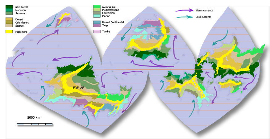
Apologies for the sketchiness of the image and some vagaries.
-----------
Let's start with Bekkai, Nan, and Rau. Dark green is rainforest, then savannah moving south, then steppe. No major disagreements with Zomp here. I've been a bit more generous with the water, and in particular I don't think there'd be desert - I think we should bear in mind the rainshadow effect. But no major issues.
Eretald, Dekhnam - yeah, humid subtropical.
Peninsular northeast of Dekhnam: again, a bit more generous, I've just gone for savannah. The mountains aren't tall, and I'm not sure about the rainshadow anyway, what with that big warm bay next door - but then, you could say that about parts of Mexico. So I guess you're free on that score.
East coast: ok, now disagreement. You've gone for continental, like America, but I'm not convinced. I think that that climate would require a proper big continent, and although this continent is large, we're effectively talking about a subcontinent here, south and east of the main mass of the continent. I think you're not going to be getting the same sort of latitudinal effects that you see in America or Asia. Instead, I think it'll have fairly mild temperatures, wet winters and moist-to-dry summers - in other words, a temperate maritime climate. I know, they're meant to be on west coasts and at higher latitudes. However, I think a good analogue here is Australia, where we see the same suptropical-->maritime progression at lower latitudes on the east coast.
Skouras: still don't trust the continentality. In particular, I think that that coastline will have a big impact on rainfall patterns. I don't see the area as being dry, at all - I think that it's going to be affected by polar-front cyclones all year round, that it's right on a very strong circumpolar current that will moisten it even more, and some differential heating will help keep it damp even in the height of summer when the PF might just leave it alone. So, that dark blue colour is subartic maritime. Think the Magellanic forests of South America. It's going to be very cold - really, really cold in winter - but nothing on the level of a continental interior. The soil shouldn't freeze, and though ordinary cereals will struggle, tubers, legumes, and some hardy cereals could be grown. It'll be fairly thick forest, but that will depend on local conditions: if the soil isn't deep enough, it may all be stripped off to make bare rock, and if the soil is deep but doesn't drain well enough, you're likely to find bogs and marshes. In exposed areas, the cold and the VERY strong winds will kill everything off; at higher altitudes, you're liable to find alpine grasslands before you go too far, and tundra higher up, particularly on the rainshadow side of the mountain.
In other words, it'll look something like this: http://upload.wikimedia.org/wikipedia/c ... rances.jpg
Xengiman: in place of the continental forests, I just went with steppe. Probably because I didn't think it would get that cold in the winters. Obviously, there'll be some foresty transition areas in east and west, and probably patches of copse and scrub all the way along that coastline.
Luduyn: back to Magellanic. Going north, through Gering, I put temperate maritime, although of course at the southern end it'll be rather colder and wetter than that, so imagine a transitional zone of Valdivian ecosystem.
The bright yellow is Mediterranean. I think you're unlikely to find it on the peninsular itself due to the strong, wet currents.
Going up through Tellinor into Vipodoh: I made the desert bigger and pushed it further north. Rainshadows near the equator can put desert right on the equator, and certainly nearby - northern Peru. On the other hand... rainshadows on the equator are pretty imposible to work out, I think. That east coast could be anything from all desert to mostly rainforest, depending on the height of the mountains, the size of the continents, and a thousand things to do with global circulations, ocean heights and El Nino effects that we don't even understand on Earth.
The centre of Erelae: yeah, steppe, with a big chunk of desert in the middle. The exact extent of the desert relative to the steppe is fairly negotiable.
-----
Arcel and Curym: I've moistened up Arcel. Northwestern Arcel will have plently of ICTZ action, and I think any rainshadows will be minimised by the orientation of the coastline. That said, I don't think it's large or high enough to form a proper monsoon. But then, the border between savannah and monsoon forest is fairly vague. That bright pink colour on the southwest is laurisilvan climate. It's mediterranean - except that I think having that great big high-pressure warm-water ocean on the southwest side is going to mean that summers are dry, rather than entirely parched. That has a big effect on vegetation. It'll become mediterranean inland - also, I guess, in areas where the coast is more north-south.
There's only meant to be one savannah colour, btw. On that picture, it looks as though there are two.
South-eastern Arcel: same as south-eastern Arelae.
Western Curym: I've shrunk the dryness. I'm guessing that that equatorial bay will have a counter-current that keeps the eastern coast of it wet. East coast of Curym: yes, I don't know what I was thinking, there should of course be rainforest in the south of it.
Neinuoi: nothing really wrong with your climates, but it depends on the height of the mountains and the wetness of the world. I think it could all be savannah.
Mediterranean and Laurisilva on the northern tip.
----
Lebiscuri: the east coast progression, if the colours aren't clear, is savannah, subtropical, desert, and steppe. Again, not buying continental. Plus rainshadow effect. I DO buy continental for the interior, which is what that light blue south of the magellanic fringe is.
The dark purple in Palthuknen is taiga, the grey is tundra.
---------
Those are just some general ideas. Basically, not too different from what you've got. The main thing is that I think the general east-west orientation, particularly around the polar front latitudes in both north and south, will lead to a wetter climate overall than our more north-south arrangement.
Blog: [url]http://vacuouswastrel.wordpress.com/[/url]
But the river tripped on her by and by, lapping
as though her heart was brook: Why, why, why! Weh, O weh
I'se so silly to be flowing but I no canna stay!
But the river tripped on her by and by, lapping
as though her heart was brook: Why, why, why! Weh, O weh
I'se so silly to be flowing but I no canna stay!
-
rotting bones
- Avisaru
- Posts: 409
- Joined: Thu Sep 07, 2006 12:25 pm
How likely is it that the Zone of Fire restores everything to a state of relative normality? Does it leak energy, or is the heat somehow magically confined within its borders? Is it centered exactly on the equator, or does it deviate at places?
If you hold a cat by the tail you learn things you cannot learn any other way. - Mark Twain
In reality, our greatest blessings come to us by way of madness, which indeed is a divine gift. - Socrates
In reality, our greatest blessings come to us by way of madness, which indeed is a divine gift. - Socrates

This is actually quite interesting to know about, because if it does remain on the equator, that would create some sort of effect on the Hadley cell dynamic during winter and summer when the ITCZ (the "natural" torrid zone) is at its farthest north or south of the "artificial" torrid Zone of Fire.rotting ham wrote:How likely is it that the Zone of Fire restores everything to a state of relative normality? Does it leak energy, or is the heat somehow magically confined within its borders? Is it centered exactly on the equator, or does it deviate at places?
Wow, thanks, Salmoneus, that's awesome. I'll go over my map again and undoubtedly move it in your direction. Thanks for looking at it in such detail.
Can you explain the wetness thing a bit more? Why would an east-west continental orientation lead to that? I need to be able to explain it to PCK readers.
Can you explain the wetness thing a bit more? Why would an east-west continental orientation lead to that? I need to be able to explain it to PCK readers.
-
Salmoneus
- Sanno
- Posts: 3197
- Joined: Thu Jan 15, 2004 5:00 pm
- Location: One of the dark places of the world
Well, I enjoy it. And... don't take my word for it! I'm not a geographer, and I haven't been working on my own maps for some time now. So talk to others. In particular, things like whether a continent is big enough for continental climates to occur are pure guesswork on my part.
However, on the theory issue, here are some reasons:
1. Iirc, it's thought that unobstructed longitudinal currents are associated with warmer earths - and warmer means wetter, all else being equal.
2. Unobstructed currents mean higher wind speeds, all else being equal. The winds and waves of the circumpolar current are the strongest anywhere on the oceans. And I suspect that's going to mean more and bigger storms hitting land, and travelling further inland. But that might be nonsense.
3. West-east orientations mean fewer rainshadow effects. Or rather, the rainshadows are less important, because the two big directional sources of rainfall (hurricanes and other tropical storms moving east-west (or west-east on countercurrents) and polar front cyclones moving west-east) won't be obstructed. Take the west coast of America. Cylones hit Oregon and Washington and parts of California... and then WHACK there's the rockies, so everything east is drier. Even if you don't have the mountains, the rainfall will peter out as you go further inland - go east from France and eventually you get to steppe. Now imagine that Canada didn't exist and the Rockies didn't exist, but that there was a mountain range just south of the 'canadian' border. Now suddenly you've got cyclones skimming the north coast of the USA all the way from Oregon to Maine, bending onto land and off the land and getting everything wet. You'd have more wet area in total than in the current alignment. Likewise, if there were no land masses directly on the equator but west-east ones just north and south, there'd be lots of rainforest and no deserts of northern peru.
4. If the continents are smaller as well as re-aligned, you won't get the same icy winters, which at some altitudes will mean more rainfall. (well, it'll always mean more rainfall prima facie, but the interaction with the rate of evaporation may be complicated).
5. Winds and currents tend to travel north-south, not east-west, except near cell boundaries. You get rain when wind travels from water to land. Stands to reason that if you have a point of land, the more land north and south of it, the less rain is likely to get to it from the north or the south.
6. Rain-bearing winds may start north-south, but they get deflected. If the wind starts going from south to north and gets deflected left (southern hemisphere) and the coast is north-south... then none of the coast gets rain. If it's deflected right, it all gets rain. But if the coast is west-east... then all of the coast gets rain all of the time, because the wind will only miss the coast if it's going west-east too, but that only happens at the ITCZ and the PF. But if there's a coastline on either of those, that'll be wet anyway due to the storm-tracks. If your land were all thin west-east strips, almost everywhere would have at least a little moisture. If all your land were thin north-south strips, they would be alternative band of [wet west dry east] and [wet east dry west]. Then if you add in seasons there'll be som variety, but you'll still get Very Wet places and Very Dry places, and monsoon effects will only add to that. West-east orientations may lead to smaller patches of Very Wet, perhaps, but a more consistent drizzle, I think.
7. North-south alignments also create north-south boundary currents. These can bring cold water toward the equator. That makes the bodies of water colder on the west coasts, reducing rainfall (cold water means colder air, so less water in it) - so even when you have onshore winds in these areas, you get less rain from it. This is how El Nino works - in northern Peru, it doesn't create any strong storms tracking from west to east, but it makes the body of water off the coast of Peru warmer, so there's more rain in the vicinity.
Of course, the opposite also happens - warm currents bring more water to other places. The east coast of North America, for instance. But the north-south alignments are going to make a more unequal distribution of rainfall.
-----
Those are my thoughts, anyway. You might want to check with someone who knows the subject properly, though.
Blog: [url]http://vacuouswastrel.wordpress.com/[/url]
But the river tripped on her by and by, lapping
as though her heart was brook: Why, why, why! Weh, O weh
I'se so silly to be flowing but I no canna stay!
But the river tripped on her by and by, lapping
as though her heart was brook: Why, why, why! Weh, O weh
I'se so silly to be flowing but I no canna stay!
OK, I revised my climate map:
I increased the Hadley cell out to about 35° and the Ferrel to about 70° to reflect the planet being somewhat warmer than Earth. Other major changes:
Palthuknen: Southern coast is maritime; moved the taiga portion north.
Lebiscuri: Largely adopted Sal's progression in the east, reflecting a rainshadow in the NE.
Curym: Shrunk the desert a bit, added Laurisilvan on the northern tip.
Arcél: Marine climate in the SE; Laurisilvan in Uytai; savannah in Fananak.
Ereláe:
Téllinor: Moved the zones north a bit.
Rau: Shrunk the desert and increased the savanna.
East coast: this is mostly Marine now (in the far south, this would be Magellanic)
Luduyn: Removed tundra.
In a number of places I seized the opportunity to divide cultural zones by climate. (E.g. I like having Uytai different from its western neighbors.)
I followed a lot of Sal's advice, but I do think he's a bit too generous with steppe— these are rarely huge zones on Earth.
(BTW, for those who suggested reversing the rotation of the planet... I considered it, but this would be equivalent to reversing north and south, and I wanted to keep the major civilizations in the southern hemisphere.)
This is still not final, though it's closer. (Also I still haven't thought about the Zone of Fire.)
-
Gremlins
- Sanci

- Posts: 59
- Joined: Wed Mar 08, 2006 1:54 pm
- Location: The western spiral arm of Great Britain (we don't have toilets)
1. Xurno wouldn't have a humid continental climate, IMO. Those mountains to the north and west will probably block most of the rain coming in. Rather Xurno, especially away from the coast, would be semi-arid and quite cold - think Patagonia rather than the Midwest.
2. Why is the central Be area rainforest but the areas further north Monsoon? Surely the whole area (apart from the northernmost bits) should have a monsoon climate? Similarly, I don't see why Fananak has a Savannah climate - it should have a climate pretty much like Uytai's, surely?
3. Why doesn't Erelae have a monsoon zone? I'd imagine the area along the coast north of the Rau, at least, would have a smaller version of the Asian Monsoon as all that desert and steppe heat up.
[quote="dinnae"][quote="Sano"]I'm a Homo sapien, does that count?[/quote]
Only if you go Erectus in the presence of the same sex.[/quote]
Only if you go Erectus in the presence of the same sex.[/quote]
Actually I think I'm missing something here. Why isn't the Midwest in a rainshadow, in fact? Just because there are no high mountains to the south?Gremlins wrote:1. Xurno wouldn't have a humid continental climate, IMO. Those mountains to the north and west will probably block most of the rain coming in. Rather Xurno, especially away from the coast, would be semi-arid and quite cold - think Patagonia rather than the Midwest.
(I wouldn't mind a more arid climate for Xengiman in fact; it would fit its history far better. I'm not sure Patagonia tells us enough, since it's very narrow. Xengiman looks more like E. North America or Asia to me.)
I figured it was too far away, but I'd actually be happy to have monsoons affect the whole area.2. Why is the central Be area rainforest but the areas further north Monsoon? Surely the whole area (apart from the northernmost bits) should have a monsoon climate?
I stole that bit from Salmoneus, so I hope he has an explanation.Similarly, I don't see why Fananak has a Savannah climate - it should have a climate pretty much like Uytai's, surely?
The coastline here is north-south— my understanding is that you need a more east-west orientation for a good monsoon.3. Why doesn't Erelae have a monsoon zone? I'd imagine the area along the coast north of the Rau, at least, would have a smaller version of the Asian Monsoon as all that desert and steppe heat up.
-
Gremlins
- Sanci
- Posts: 59
- Joined: Wed Mar 08, 2006 1:54 pm
- Location: The western spiral arm of Great Britain (we don't have toilets)
IIRC what makes the middle of America humid is that there's nothing stopping polar fronts pushing south down the middle/equatorial fronts pushing north. This is why rain is generally accompanied by strong winds in North America?zompist wrote:Actually I think I'm missing something here. Why isn't the Midwest in a rainshadow, in fact? Just because there are no high mountains to the south?Gremlins wrote:1. Xurno wouldn't have a humid continental climate, IMO. Those mountains to the north and west will probably block most of the rain coming in. Rather Xurno, especially away from the coast, would be semi-arid and quite cold - think Patagonia rather than the Midwest.
(I wouldn't mind a more arid climate for Xengiman in fact; it would fit its history far better. I'm not sure Patagonia tells us enough, since it's very narrow. Xengiman looks more like E. North America or Asia to me.)
Tropical climates which are wet all year round are closer to the equator than tropical climates with wet and dry seasons; northern Arcel would probably fall into the latter category, similar to West Africa.I figured it was too far away, but I'd actually be happy to have monsoons affect the whole area.2. Why is the central Be area rainforest but the areas further north Monsoon? Surely the whole area (apart from the northernmost bits) should have a monsoon climate?
Well, I assume it would just be the same the rest of Arcel's south coast; I can't imagine why it *wouldn't* be.I stole that bit from Salmoneus, so I hope he has an explanation.Similarly, I don't see why Fananak has a Savannah climate - it should have a climate pretty much like Uytai's, surely?
[/quote]The coastline here is north-south— my understanding is that you need a more east-west orientation for a good monsoon.3. Why doesn't Erelae have a monsoon zone? I'd imagine the area along the coast north of the Rau, at least, would have a smaller version of the Asian Monsoon as all that desert and steppe heat up.
Hm, I'm not sure of this. Neither India nor East Asia have particularly east-west coastlines. In summer the winds will blow towards the centre of Erelae as it heats up, presumably moving from north-west to south-east (the same way the East Asian monsoon goes from south-west to north-east), and presumably the mountains just north of the Rau are probably big enough to cause uplift precipitation. In the winter you'd probably get an effect similar to the Harmattan winds.
[quote="dinnae"][quote="Sano"]I'm a Homo sapien, does that count?[/quote]
Only if you go Erectus in the presence of the same sex.[/quote]
Only if you go Erectus in the presence of the same sex.[/quote]
The Gulf of Mexico, and troughing in the lee of the Rockies.zompist wrote: Actually I think I'm missing something here. Why isn't the Midwest in a rainshadow, in fact? Just because there are no high mountains to the south?
The presence of a large body of water allows a tropical maritime air mass to build up and come ashore, funneled between the Appalachians and the Rockies. This is generally opposed by continental polar air masses coming down from Canada and the northern U.S. having been formed or strengthened by leaving the Rockies - for reasons relating to the conservation of angular momentum, an air mass leaving the Rockies tends to result in a low spinning up as it goes eastward. You end up with a cold front where the dry, cold continental polar air is encroaching upon the warm, moist tropical air - and since "warm air rises," this produces clouds, convection, and thunderstorms with rain. A similar thing happens with the warm front that is produced where the moist tropical air is overtaking the cold polar air - it slides over the polar air, condensing into clouds and precipitation.