Didn't think I was going to do this, but what the hell. Haven't made a continent in ages.
Please excuse the impressionistic design, and sorry, I forgot there'd be that whitespace there.
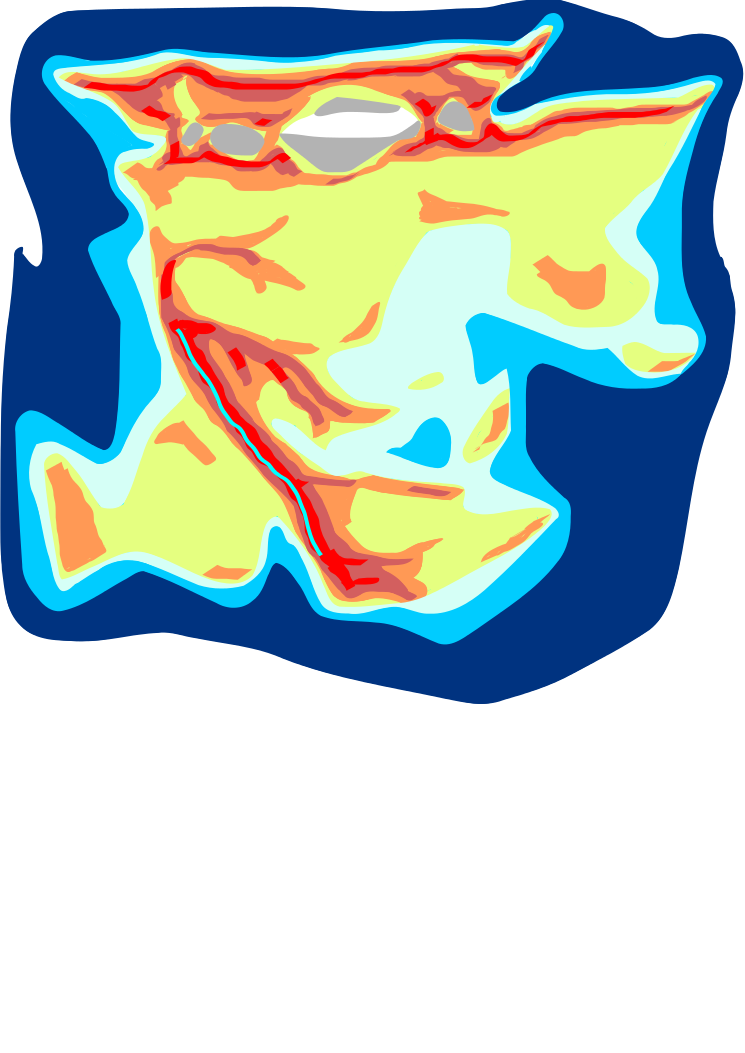
I've tried for something both interesting and realistic. As you can see, it's a merger of three plates, in the process of colliding - a small subcontinent on the bottom left (I've no attachment re: north and south, east/west), a big continent in the centre, and a little ribbon of a subcontinent at the top. There are three major orogenies going on here (the paler orange is just 'uplands' and hill country, the darker puce is serious mountains, the red is really serious mountains, and the thin pale line is the really, really serious mountains):
- the huge mountain chain in the bottom left, with the ridge of really high mountains, caused by the arrival of the subcontinent (see India)
- the mountains either side of the juncture between the main and the topmost landmasses. There was a sea here, but it's almost entirely been eaten up...
- the mountains right at the top (and at the top left), standard mountains caused by the ocean plate hitting the continental margin
Apart from that, I'd mention two things:
a) the large shallow sea at right (pale blue, turns out it looks a bit too green, sorry about that), probably has a lot of little islands in
b) where the main and top plates are colliding, there are a number of trapped seabasins. These, inevitably, have dried up (like the old mediterranean). The grey areas were shallow seas (or at least were once the mountainbuilding had a go at them) - these areas are below sea level but not much, and dry. Think dead sea. The white area is exposed deep seabed, again like the old mediterranean - long way down, hot as hell, thick air, all salt flat.
The dry seas/lakes may appear weird, but they're a perfectly natural phenomenon that has occured on earth within the very recent (i.e. thousands, not millions, of years) past. We just happen not to have them at the moment. If we looked at this continent a ten million years earlier, we'd probably just see a mediterranean-like sea; if we looked ten million years later, I guess it would all just look like the Rockies. This is what you get in between...
Anyway, the idea is that this continent would offer plenty of diversity: you've got multiple open flat areas that early on would be mostly independent from one another, you've got possibilities for seafaring at the right there (both the shallow sea and the peninsulars around it) (there's also a couple of places where you could reasonably stick on some archipelagos about the place if you wanted), and you've got something weird going on up at the top.
Hope you like.


