
This is a thread about maps that are bad, not in appearance, but in content, maps that look all professional but are actually a game of "what is wrong with this picture".
Here is an example:
http://upload.wikimedia.org/wikipedia/c ... gue-en.svg
This map is meant to represent the progression of the black death in Europe in the high middle ages.
Except it uses modern borders, which would be bad enough if these were *actual* modern borders, but those are obsolete borders from 2005, showing Serbia and Montenegro still as a single country. But wait, there's more, and in a same area: for some unassessable reason, it also shows the Vojvodina autonomous region of Serbia as a sovereign country!
The bad maps thread.
-
Drydic

- Smeric

- Posts: 1652
- Joined: Tue Oct 08, 2002 12:23 pm
- Location: I am a prisoner in my own mind.
- Contact:
Re: The bad maps thread.
I think I figured out why Vojvodina is marked off. Look at the Netherlands, specifically the Rhine delta (the mouths of the Danube are also visible). They mark major rivers. Unfortunately they also are inconsistent with that :/


-
Salmoneus

- Sanno

- Posts: 3197
- Joined: Thu Jan 15, 2004 5:00 pm
- Location: One of the dark places of the world
Re: The bad maps thread.
I'm not sure using modern borders is necessarily a problem in this case, as they're just there for guidance, they don't shape the info. (though yes, adding a new country is weird).
I was recently having similar problems with America, though. Maps of American history tend to be appalling - they tend to assume that the States are inviolable and eternal, so they show states leaving and joining the US, but not having the borders changed...
Take this one, for instance:

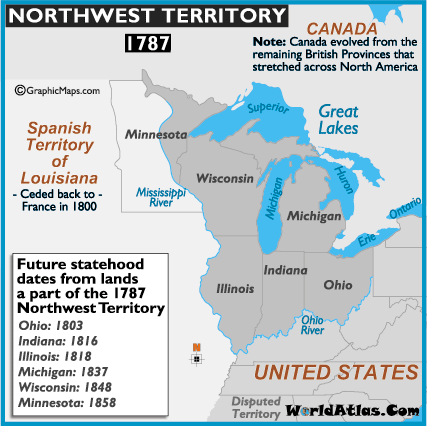
"Northwest Territory, 1787", it says.
Well, well done for noting that there was only one Virginia in 1787. [EDIT: hang on, Kentucky didn't exist in 1787 either, it was all Virginia at this point. And Tennessee didn't exist either, it was unorganised territory.] You've put 'MAINE' on the label as though it were a state, but ok, you've at least put in brackets that it's part of Massachusetts at this point. Don't know why Vermont isn't labelled and Vermont and New Hampshire lack their borders with New York, but I guess that's just a typo.
And well done, you've recognised that the country to the west is Spanish Louisiana, and that the country to the north is British North America. I mean sure, it's at least three different countries at this time, and even collectively nobody around at the time actually called them 'British North America', but never mind, I guess that's pedantry. And you show the modern Maine-New Brunswick-Quebec borders, which hadn't yet been agreed on, but lets not confuse people's minds with tiny little details of no historical significance.
But other than state, the State borders are given as they are now. This overlooks the fact that a) Ohio, Illinois, Michigan, Indiana, Wisconsin and Minnesota didn't exist in 1787, b) the territory was provisionally divided up differently, and c) when the states were formed out of the territory, they didn't have those exact borders. So although it's a map of 1787, and serves no purpose other than to tell you about north america circa 1787, it doesn't actually reflect the status quo of 1787.
Even worse than that: it doesn't even correctly show the borders of the Northwest Territory itself, since, obsessed with the modern borders, it includes New Connecticut, which hadn't yet been ceded...
Oh, and Vermont is shown (unlabelled) as part of the US. In reality, Vermont would remain an independent country for several more years before joining the Union. Maybe that's why there's no Vermont on the map - perhaps they knew that Vermont hadn't joined yet, but just refused to accept that the area that's now vermont hasn't been part of the US since the days of Jesus?
[both the Vermont thing and the Northwest Territory thing are common problems with US historical maps. I didn't look hard for this one, and it's not one that I saw before, it's just what popped up when I googled]
EDIT:
here's another:
1787, says the title at the top. And they're so conscientious about outside the US borders, noting for instance that 'Canada' doesn't technically exist yet. They even note, within the US, that bit of disputed (by Georgia, iirc) territory. But they use modern state boundaries! It's not even as though they're just doing it to remind people where Michigan is, because they even include West Virginia!
I was recently having similar problems with America, though. Maps of American history tend to be appalling - they tend to assume that the States are inviolable and eternal, so they show states leaving and joining the US, but not having the borders changed...
Take this one, for instance:
"Northwest Territory, 1787", it says.
Well, well done for noting that there was only one Virginia in 1787. [EDIT: hang on, Kentucky didn't exist in 1787 either, it was all Virginia at this point. And Tennessee didn't exist either, it was unorganised territory.] You've put 'MAINE' on the label as though it were a state, but ok, you've at least put in brackets that it's part of Massachusetts at this point. Don't know why Vermont isn't labelled and Vermont and New Hampshire lack their borders with New York, but I guess that's just a typo.
And well done, you've recognised that the country to the west is Spanish Louisiana, and that the country to the north is British North America. I mean sure, it's at least three different countries at this time, and even collectively nobody around at the time actually called them 'British North America', but never mind, I guess that's pedantry. And you show the modern Maine-New Brunswick-Quebec borders, which hadn't yet been agreed on, but lets not confuse people's minds with tiny little details of no historical significance.
But other than state, the State borders are given as they are now. This overlooks the fact that a) Ohio, Illinois, Michigan, Indiana, Wisconsin and Minnesota didn't exist in 1787, b) the territory was provisionally divided up differently, and c) when the states were formed out of the territory, they didn't have those exact borders. So although it's a map of 1787, and serves no purpose other than to tell you about north america circa 1787, it doesn't actually reflect the status quo of 1787.
Even worse than that: it doesn't even correctly show the borders of the Northwest Territory itself, since, obsessed with the modern borders, it includes New Connecticut, which hadn't yet been ceded...
Oh, and Vermont is shown (unlabelled) as part of the US. In reality, Vermont would remain an independent country for several more years before joining the Union. Maybe that's why there's no Vermont on the map - perhaps they knew that Vermont hadn't joined yet, but just refused to accept that the area that's now vermont hasn't been part of the US since the days of Jesus?
[both the Vermont thing and the Northwest Territory thing are common problems with US historical maps. I didn't look hard for this one, and it's not one that I saw before, it's just what popped up when I googled]
EDIT:
here's another:
1787, says the title at the top. And they're so conscientious about outside the US borders, noting for instance that 'Canada' doesn't technically exist yet. They even note, within the US, that bit of disputed (by Georgia, iirc) territory. But they use modern state boundaries! It's not even as though they're just doing it to remind people where Michigan is, because they even include West Virginia!
Blog: [url]http://vacuouswastrel.wordpress.com/[/url]
But the river tripped on her by and by, lapping
as though her heart was brook: Why, why, why! Weh, O weh
I'se so silly to be flowing but I no canna stay!
But the river tripped on her by and by, lapping
as though her heart was brook: Why, why, why! Weh, O weh
I'se so silly to be flowing but I no canna stay!

Re: The bad maps thread.
You can add that Kentucky and Tennessee weren't states yet (admitted 1792 and 1796, respectively).
-
Salmoneus
- Sanno
- Posts: 3197
- Joined: Thu Jan 15, 2004 5:00 pm
- Location: One of the dark places of the world
Re: The bad maps thread.
Yeah, caught that in edit. Also that part of what they show as Northwest Territory was actually Connecticut at the time.zompist wrote:You can add that Kentucky and Tennessee weren't states yet (admitted 1792 and 1796, respectively).
Blog: [url]http://vacuouswastrel.wordpress.com/[/url]
But the river tripped on her by and by, lapping
as though her heart was brook: Why, why, why! Weh, O weh
I'se so silly to be flowing but I no canna stay!
But the river tripped on her by and by, lapping
as though her heart was brook: Why, why, why! Weh, O weh
I'se so silly to be flowing but I no canna stay!
-
Drydic
- Smeric
- Posts: 1652
- Joined: Tue Oct 08, 2002 12:23 pm
- Location: I am a prisoner in my own mind.
- Contact:
Re: The bad maps thread.
Vermont was claimed by both New York and New Hampshire until its admission as a state, and parts were in some measure controlled by them (I'm hazy on those specifics, sorry). And the river running down New Hampshire is the border.Salmoneus wrote:Don't know why Vermont isn't labelled and Vermont and New Hampshire lack their borders with New York, but I guess that's just a typo.
Oh, and Vermont is shown (unlabelled) as part of the US. In reality, Vermont would remain an independent country for several more years before joining the Union. Maybe that's why there's no Vermont on the map - perhaps they knew that Vermont hadn't joined yet, but just refused to accept that the area that's now vermont hasn't been part of the US since the days of Jesus?
-
HandsomeRob

- Lebom

- Posts: 76
- Joined: Tue Jan 10, 2006 9:54 am
- Location: Wisconsin
- Contact:

Re: The bad maps thread.
Here's a map of annual tornado incidence in the US. Note in particular the epicenter of Tornado Alley, where Texas has magically annexed most of southern Oklahoma. The boundaries of some northern border states are kind of shitty, too.

Last edited by dhok on Sun Dec 15, 2013 11:10 am, edited 1 time in total.
Re: The bad maps thread.
For some reason West Virginia looks weird to me. I think it's the southern border...
Un llapis mai dibuixa sense una mà.
-
Hallow XIII
- Avisaru

- Posts: 846
- Joined: Sun Nov 04, 2012 3:40 pm
- Location: Under Heaven
Re: The bad maps thread.
Boy have I got a treat for you.
There is so much wrong with this I don't even know where to start. The utterly misshapen Scandinavia labelled "ENGLAND" in fat red letters is the slightest issue.
There is so much wrong with this I don't even know where to start. The utterly misshapen Scandinavia labelled "ENGLAND" in fat red letters is the slightest issue.
陳第 wrote:蓋時有古今,地有南北;字有更革,音有轉移,亦勢所必至。
Read all about my excellent conlangsR.Rusanov wrote:seks istiyorum
sex want-PRS-1sg
Basic Conlanging Advice
Re: The bad maps thread.
Are you sure it's not from a parallel universe?Hallow XIII wrote:Boy have I got a treat for you.
There is so much wrong with this I don't even know where to start. The utterly misshapen Scandinavia labelled "ENGLAND" in fat red letters is the slightest issue.

Re: The bad maps thread.
Things I spot:Boy have I got a treat for you.
There is so much wrong with this I don't even know where to start. The utterly misshapen Scandinavia labelled "ENGLAND" in fat red letters is the slightest issue.
1) Iceland is part of North America now? (Seriously though, iirc doesn't it actually straddle the plates of both Europe and North America?)
2) Only the right half of Papua New Guinea is part of Australia.
3) Corsica, Sardinia, Sicily, Cyprus, and Sri Lanka don't exist. (Arne't they all bigger than Hawaii?, which is shown.)
-
KathTheDragon

- Smeric
- Posts: 2139
- Joined: Thu Apr 25, 2013 4:48 am
- Location: Brittania
Re: The bad maps thread.
The Persian Gulf and the Gulf of Oman have dried up.
The Black and Caspian Seas have dried up.
The Great Lakes have dried up.
And Antarctica has changed shape.
The Black and Caspian Seas have dried up.
The Great Lakes have dried up.
And Antarctica has changed shape.
-
Hallow XIII
- Avisaru
- Posts: 846
- Joined: Sun Nov 04, 2012 3:40 pm
- Location: Under Heaven
Re: The bad maps thread.
You will also notice that this map features a British peninsula, rather than British isles, and Ireland doesn't exist; furthermore, the Asian Pacific coastline is completely disfigured.
陳第 wrote:蓋時有古今,地有南北;字有更革,音有轉移,亦勢所必至。
Read all about my excellent conlangsR.Rusanov wrote:seks istiyorum
sex want-PRS-1sg
Basic Conlanging Advice

Re: The bad maps thread.
I'm not sure if this one is too egregious. You're referring to the right half of the island of New Guinea, which is part of the country of Papua New Guinea (here grouped with "Oceania"). The left part of the island of New Guinea is part of Indonesia, which is traditionally grouped with Asia rather than Oceania.Terra wrote:2) Only the right half of Papua New Guinea is part of Australia.
Re: The bad maps thread.
Where did you find that map, H13? Is it part of a larger something, like an information panel?
Un llapis mai dibuixa sense una mà.
-
Hallow XIII
- Avisaru
- Posts: 846
- Joined: Sun Nov 04, 2012 3:40 pm
- Location: Under Heaven
Re: The bad maps thread.
Chinese History Course. That's why the quality is so shit, it was beamed onto a canvas and I photographed it with my phone.
When I pointed out that the map was wrong the teacher's first assumption was that I might be disconcerted by the Pacific not being in the middle like on normal maps. Ah, the Chinese.
When I pointed out that the map was wrong the teacher's first assumption was that I might be disconcerted by the Pacific not being in the middle like on normal maps. Ah, the Chinese.
陳第 wrote:蓋時有古今,地有南北;字有更革,音有轉移,亦勢所必至。
Read all about my excellent conlangsR.Rusanov wrote:seks istiyorum
sex want-PRS-1sg
Basic Conlanging Advice
Re: The bad maps thread.
For some reason I thought *Papua* New Guinea referred to the island, not the country. Sorry.The left part of the island of New Guinea is part of Indonesia, which is traditionally grouped with Asia rather than Oceania.
Also, yeah, the political situation is at least some reason to group the eastern half with Oceania, but then why's Iceland grouped with North America? This map can't decide how it wants to group things.
Is the Pacific Ocean actually usually in the middle on Chinese maps? (It would make sense, from China's perspective, at least...)When I pointed out that the map was wrong the teacher's first assumption was that I might be disconcerted by the Pacific not being in the middle like on normal maps. Ah, the Chinese.
-
Hallow XIII
- Avisaru
- Posts: 846
- Joined: Sun Nov 04, 2012 3:40 pm
- Location: Under Heaven
Re: The bad maps thread.
Yes, they look like this:

陳第 wrote:蓋時有古今,地有南北;字有更革,音有轉移,亦勢所必至。
Read all about my excellent conlangsR.Rusanov wrote:seks istiyorum
sex want-PRS-1sg
Basic Conlanging Advice
Re: The bad maps thread.
The picture isn't showing.
Anyways, was what you were going to show basically what you get if you google images for "chinese world map"?
Anyways, was what you were going to show basically what you get if you google images for "chinese world map"?
-
Herra Ratatoskr

- Avisaru
- Posts: 308
- Joined: Thu Mar 25, 2004 5:26 pm
- Location: Missouri (loves company!)
Re: The bad maps thread.
The site it's on blocks embedding. You can see it by going to http://pic.nipic.com/2007-12-18/2007121817209621_2.jpg.
I am Ratatosk, Norse Squirrel of Strife!
There are 10 types of people in this world:
-Those who understand binary
-Those who don't
Mater tua circeta ibat et pater tuus sambucorum olficiebat!
There are 10 types of people in this world:
-Those who understand binary
-Those who don't
Mater tua circeta ibat et pater tuus sambucorum olficiebat!
-
Hallow XIII
- Avisaru
- Posts: 846
- Joined: Sun Nov 04, 2012 3:40 pm
- Location: Under Heaven
Re: The bad maps thread.
Strange. It displays for me.
陳第 wrote:蓋時有古今,地有南北;字有更革,音有轉移,亦勢所必至。
Read all about my excellent conlangsR.Rusanov wrote:seks istiyorum
sex want-PRS-1sg
Basic Conlanging Advice
-
Drydic
- Smeric
- Posts: 1652
- Joined: Tue Oct 08, 2002 12:23 pm
- Location: I am a prisoner in my own mind.
- Contact:
Re: The bad maps thread.
You're in China.Hallow XIII wrote:Strange. It displays for me.
I get this from clicking on the link:
错误
您所请求的网址(URL)无法获取
当尝试读取以下网址(URL)时: http://icon.nipic.com/block.gif
发生了下列的错误:
Access Denied.
拒绝访问
Access control configuration prevents your request from being allowed at this time. Please contact your service provider if you feel this is incorrect.
当前的存取控制设定禁止您的请求被接受, 如果您觉得这是错误的,请与您网路服务的提供者联系。
本缓存服务器管理员:support@chinacache.com
