I'm not sure using modern borders is necessarily a problem in this case, as they're just there for guidance, they don't shape the info. (though yes, adding a new country is weird).
I was recently having similar problems with America, though. Maps of American history tend to be appalling - they tend to assume that the States are inviolable and eternal, so they show states leaving and joining the US, but not having the borders changed...
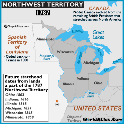
Take this one, for instance:

"Northwest Territory, 1787", it says.
Well, well done for noting that there was only one Virginia in 1787. [EDIT: hang on, Kentucky didn't exist in 1787 either, it was all Virginia at this point. And Tennessee didn't exist either, it was unorganised territory.] You've put 'MAINE' on the label as though it were a state, but ok, you've at least put in brackets that it's part of Massachusetts at this point. Don't know why Vermont isn't labelled and Vermont and New Hampshire lack their borders with New York, but I guess that's just a typo.
And well done, you've recognised that the country to the west is Spanish Louisiana, and that the country to the north is British North America. I mean sure, it's at least three different countries at this time, and even collectively nobody around at the time actually called them 'British North America', but never mind, I guess that's pedantry. And you show the modern Maine-New Brunswick-Quebec borders, which hadn't yet been agreed on, but lets not confuse people's minds with tiny little details of no historical significance.
But other than state, the State borders are given as they are now. This overlooks the fact that a) Ohio, Illinois, Michigan, Indiana, Wisconsin and Minnesota didn't exist in 1787, b) the territory was provisionally divided up differently, and c) when the states were formed out of the territory, they didn't have those exact borders. So although it's a map of 1787, and serves no purpose other than to tell you about north america circa 1787, it doesn't actually reflect the status quo of 1787.
Even worse than that: it doesn't even correctly show the borders of the Northwest Territory itself, since, obsessed with the modern borders, it includes New Connecticut, which hadn't yet been ceded...
Oh, and Vermont is shown (unlabelled) as part of the US. In reality, Vermont would remain an independent country for several more years before joining the Union. Maybe that's why there's no Vermont on the map - perhaps they knew that Vermont hadn't joined yet, but just refused to accept that the area that's now vermont hasn't been part of the US since the days of Jesus?
[both the Vermont thing and the Northwest Territory thing are common problems with US historical maps. I didn't look hard for this one, and it's not one that I saw before, it's just what popped up when I googled]
EDIT:
here's another:
1787, says the title at the top. And they're so conscientious about outside the US borders, noting for instance that 'Canada' doesn't technically exist yet. They even note, within the US, that bit of disputed (by Georgia, iirc) territory. But they use modern state boundaries! It's not even as though they're just doing it to remind people where Michigan is, because they even include West Virginia!

