Conlang relay [relocated] (aka "The Cursed Relay")

Substantial postings about constructed languages and constructed worlds in general. Good place to mention your own or evaluate someone else's. Put quick questions in C&C Quickies instead.
User avatar
Radius Solis
Smeric
Smeric
Posts: 1248
Joined: Tue Mar 30, 2004 5:40 pm
Location: Si'ahl
Contact:

Post by Radius Solis »

That is very nice! :D But if you are going to add Theduke's corrections, there's a couple other things that should be changed too:

- The big river west of where you put Xshalad should enter the sea further east, not at the head of that gulf. There's a little V-shaped bay in the north coast of the gulf, due south of the N of Rathedan; that'd be about perfect. Elevation might need to change a bit to accomodate this.

- The Xshalad empire is centered on the lower reaches of this river, on its floodplain.

- The Rathedan label is a bit too far to the west. The middle of it should be right about where the N is.


As far as I can see, everything else is good, though Cedh may notice things I've missed. Also, welcome back!

User avatar
A pocketful of songs.
Sanci
Sanci
Posts: 15
Joined: Sun Dec 11, 2005 1:12 am

Post by A pocketful of songs. »

Thanks, you guys. I'll start on the corrections in a little while. But about the Kipceʔ being where the 'Coastal Corridor' label is, how would there be a desert in that piedmont type of situation? Do you mean inland, in the mountains?

Cedh
Sanno
Sanno
Posts: 938
Joined: Tue Nov 14, 2006 10:30 am
Location: Tübingen, Germany
Contact:

Post by Cedh »

A pocketful of songs. wrote:Thanks, you guys. I'll start on the corrections in a little while. But about the Kipceʔ being where the 'Coastal Corridor' label is, how would there be a desert in that piedmont type of situation? Do you mean inland, in the mountains?
No, coastal, like in Chile.

I'll comment with more details later today.

User avatar
A pocketful of songs.
Sanci
Sanci
Posts: 15
Joined: Sun Dec 11, 2005 1:12 am

Post by A pocketful of songs. »


Cedh
Sanno
Sanno
Posts: 938
Joined: Tue Nov 14, 2006 10:30 am
Location: Tübingen, Germany
Contact:

Post by Cedh »

I wrote:I'll comment with more details later today.
First of all: Welcome back, Mr. Pocketful! Your map is really cool! I almost missed my train this morning because of examining it ;)

The labels are in the correct positions now. The Western Steppe region looks a bit too dry now though, with all those rivers being seasonal. I think this region could also benefit from some height relief.

Also, I'm not sure which of the world maps you based this on, but it appears you didn't use the latest one. If you look closely, some minor things have changed:
- The island of Fmana-hŋ-Talam has been turned and moved west.
- Some coastlines of islands in the Sumarušuxi region have been modified. Notably, Ik'im is much smaller now.
- A few islands have been added in the Qedik region to better account for the tectonic scenario.
- The eastern Šišin Mountains should probably be a bit closer to the southern coast.
- I've been working on a satellite-style map of Siixtaguna recently, and I'm considering some changes to the NW coast of that subcontinent (mostly to make the landforms better-looking in an orthographic projection; the world map suffers from some polar distortion there when projected on a sphere). It would be great if we could collaborate here. In any case, your heightfield lines will be very useful for creating a realistic-looking relief.
Last edited by Cedh on Wed May 05, 2010 2:33 pm, edited 1 time in total.

User avatar
Mbwa
Lebom
Lebom
Posts: 142
Joined: Sat Aug 18, 2007 1:48 pm

Post by Mbwa »

I'll put up a brief sketch of my Lukpanic language later today.

User avatar
the duke of nuke
Avisaru
Avisaru
Posts: 467
Joined: Thu Apr 06, 2006 1:23 pm
Location: Leicestershire
Contact:

Post by the duke of nuke »

A couple more maps.

Most importantly: a version of the Lukpanic map with ethnic groups in about -500 YP. Locations are tentative and I'll change them if they don't work, but I've assigned them based on descriptions in the grammars. Some, like the Wañelinlawag Empire, are reasonably firm - it looks like descendants of Alces' Naəgbum dialect will end up being the most important languages of the late 1st millennium BP due to interaction with the said Empire, which reaches its height at the time of the map.

Also: a map of the sea east of Peilaš, with major cultures as of 400 YP. Athalē, Huyfárah, and Affalinnei are correctly placed, but the others are tentative.
XinuX wrote:I learned this language, but then I sneezed and now am in prison for high treason. 0/10 would not speak again.

Cedh
Sanno
Sanno
Posts: 938
Joined: Tue Nov 14, 2006 10:30 am
Location: Tübingen, Germany
Contact:

Post by Cedh »

thedukeofnuke wrote:Also: a map of the sea east of Peilaš, with major cultures as of 400 YP. Athalē, Huyfárah, and Affalinnei are correctly placed, but the others are tentative.
The Mûtsinamtsys are based one group of islands further south. Where you have them, there should be the Máotatšàlì. Also, shortly after 400 YP is the heyday of the Kennan, which your map leaves out entirely so far.

For a diagram of who's where at what time, see also this page, which Corumayas and I prepared a few weeks ago.

User avatar
Mbwa
Lebom
Lebom
Posts: 142
Joined: Sat Aug 18, 2007 1:48 pm

Post by Mbwa »

I do have a sketch of the phonology of an older stage of a Lukpanic language, though I realize the Lukpanic languages are kinda insignifigant. More work will probably be added. I need to figure out how to make articles though.

zompist
Boardlord
Boardlord
Posts: 3368
Joined: Thu Sep 12, 2002 8:26 pm
Location: In the den
Contact:

Post by zompist »

That's quite a gorgeous map.

And it reminds me that I am very unlikely to get back to the Wippwô (Stinking Mud) people, my derivative of Radius's Naidda. So I'd be happy if someone else took it over.

What I have is basically the sound changes and a hand-tweaked lexicon of about 1300 words, which could be a good starting point. Any takers?

User avatar
the duke of nuke
Avisaru
Avisaru
Posts: 467
Joined: Thu Apr 06, 2006 1:23 pm
Location: Leicestershire
Contact:

Post by the duke of nuke »

cedh audmanh wrote:
thedukeofnuke wrote:Also: a map of the sea east of Peilaš, with major cultures as of 400 YP. Athalē, Huyfárah, and Affalinnei are correctly placed, but the others are tentative.
The Mûtsinamtsys are based one group of islands further south. Where you have them, there should be the Máotatšàlì. Also, shortly after 400 YP is the heyday of the Kennan, which your map leaves out entirely so far.

For a diagram of who's where at what time, see also this page, which Corumayas and I prepared a few weeks ago.
Thanks. The omission of the Kennan was intentional - it's supposed to be a map immediately before their greatest wave of expansion - but I could certainly put in something to indicate that... hmm.
The other errors I shall correct. That link will be useful.
Mbwa wrote:I do have a sketch of the phonology of an older stage of a Lukpanic language, though I realize the Lukpanic languages are kinda insignifigant. More work will probably be added. I need to figure out how to make articles though.
That's not too hard. For instance, if you want to create a page called, I don't know, Terence, then put the address
http://akana.superlush.co.uk/~akana/index.php/Terence
into your web browser and click "edit this page". You can also move it (i.e. change the page name) once it's started.
Terence isn't a very good name for a language, but you get the idea.
XinuX wrote:I learned this language, but then I sneezed and now am in prison for high treason. 0/10 would not speak again.

User avatar
Nortaneous
Sumerul
Sumerul
Posts: 4544
Joined: Mon Apr 13, 2009 1:52 am
Location: the Imperial Corridor

Post by Nortaneous »

thedukeofnuke wrote:Terence isn't a very good name for a language, but you get the idea.
ahaha, someday I will make a conlang called Terence
Siöö jandeng raiglin zåbei tandiüłåd;
nää džunnfin kukuch vklaivei sivei tåd.
Chei. Chei. Chei. Chei. Chei. Chei. Chei.

User avatar
Arzena
Lebom
Lebom
Posts: 240
Joined: Sat Jun 14, 2008 1:19 pm
Location: ¡California, Tejas, Marruecos!

Post by Arzena »

zompist wrote: And it reminds me that I am very unlikely to get back to the Wippwô (Stinking Mud) people, my derivative of Radius's Naidda. So I'd be happy if someone else took it over.

What I have is basically the sound changes and a hand-tweaked lexicon of about 1300 words, which could be a good starting point. Any takers?
I'll take you up on your offer.
A New Yorker wrote:Isn't it sort of a relief to talk about the English Premier League instead of the sad state of publishing?
Abi wrote:At this point it seems pretty apparent that PIE was simply an ancient esperanto gone awry.
Shtåså, Empotle7á, Neire Wippwo

Corumayas
Avisaru
Avisaru
Posts: 357
Joined: Sat Jul 30, 2005 3:45 pm
Location: San Francisco

Post by Corumayas »

Yay thread revival! Yay new contributors! Yay past contributors coming back for more! Welcome welcome!

(I seem to be finding myself somehow more (pre)occupied these days than in the past, but I'm still around, reading everything and working on stuff in my slowpoke way. I keep thinking I should drop by #akana sometime, but I've been putting it off because it seems like when I do, I always spend the whole afternoon there...)


Anyway, some questions and comments:

A pocketful of songs. wrote:Corrected.
I believe the region you've labelled "Western Plateau" is where the Zmůwø Mountains are. Also, the Rathedān proper is still slightly further east than you put it: it should basically comprise the highlands between the Thabīa, Milīr, and Aiwa valleys (thus it doesn't extend west of the Thabīa at all).

I'm also not sure where all those tiny lakes are coming from... they look a little excessive to me. I think a lot of the lakes along rivers on Earth are artificial, created by modern dams. (Maybe what I'm reacting to is more the style of map than the content though-- I find all those little fiddly lines kind of busy-looking.)

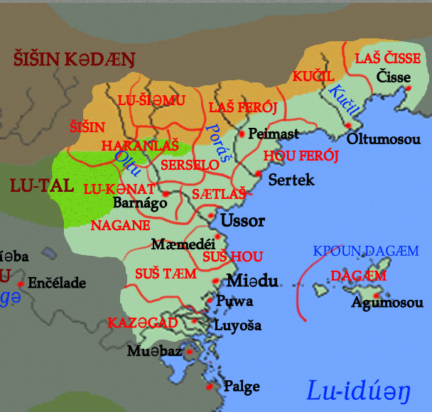
Radius Solis wrote:- The big river west of where you put Xshalad should enter the sea further east, not at the head of that gulf. ... The Xshalad empire is centered on the lower reaches of this river, on its floodplain.
Is this river still called the Yima?

cedh audmanh wrote:The Western Steppe region looks a bit too dry now though, with all those rivers being seasonal. I think this region could also benefit from some height relief.
I agree. Actually, it seems like we need a Western Coastal Range to cast a rainshadow over the steppe-- otherwise it should mostly be forest, like western Europe, shouldn't it?
cedh audmanh wrote:Also, I'm not sure which of the world maps you based this on, but it appears you didn't use the latest one.
I've been using this map as a base map for my own sketching purposes, but I've noticed it's a little different than the one with tectonics-- I take it the tectonics one is more correct then?
- Some coastlines of islands in the Sumarušuxi region have been modified. Notably, Ik'im is much smaller now.
I've wondered why you did this, actually-- do you remember the reason?
- I've been working on a satellite-style map of Siixtaguna recently ...
Wow. Sounds cool!

thedukeofnuke wrote:Most importantly: a version of the Lukpanic map with ethnic groups in about -500 YP. Locations are tentative and I'll change them if they don't work, but I've assigned them based on descriptions in the grammars. Some, like the Wañelinlawag Empire, are reasonably firm - it looks like descendants of Alces' Naəgbum dialect will end up being the most important languages of the late 1st millennium BP due to interaction with the said Empire, which reaches its height at the time of the map.
My first reaction is that the Lukpanic cities seem awfully spread out. Sure, they could trade over that whole area; but surely just one part of it is their homeland, and most of their cities should be clustered there. (It seems to me that the most likely place for such a cluster is the peninsula where you've placed Kpitamoa, including the island Poalugbum is on. I'd suggest putting more of the cities there.)

I have more to say about the whole Western scenario, but I think I'll save it for a little later-- it needs its own post, if not its own thread on the Akana forum.
Also: a map of the sea east of Peilaš, with major cultures as of 400 YP. Athalē, Huyfárah, and Affalinnei are correctly placed, but the others are tentative.
In addition to the correction noted by Cedh, it looks like you too have placed Xšalad too far east. (I'm not clear on exactly where its borders are though...)


Despite my nitpicking though, I have to say all these maps are lovely and I'm happy to see so much new activity in Akana!


By the by...
zompist wrote:That's quite a gorgeous map.

And it reminds me that I am very unlikely to get back to the Wippwô (Stinking Mud) people, my derivative of Radius's Naidda. So I'd be happy if someone else took it over.
While we have your attention, is there any chance you could spend a few minutes looking over this? The main question is how Fáralo would borrow the island name /wAnEnu~tEjE~/, but if you approve or disapprove of anything else in that post it'd be nice to know.
(
A few months ago, you wrote:Oops, someone did point out the Fáralo questions to me, and I've been forgetting about them. I'll try to respond in a few days.
)
Thanks!
Hüwryaasûr, priestess of the four hegemons, wrote:Ryunshurshuroshan, the floating lizard

Akana Wiki | Akana Forum

User avatar
A pocketful of songs.
Sanci
Sanci
Posts: 15
Joined: Sun Dec 11, 2005 1:12 am

Post by A pocketful of songs. »


zompist
Boardlord
Boardlord
Posts: 3368
Joined: Thu Sep 12, 2002 8:26 pm
Location: In the den
Contact:

Post by zompist »

Ah, sure. Here's a map of the provinces in the classical empire:

Image

Oltu valley:
Šišin 'north', Lu-šiəmu 'the upperness'
Haranlaš 'Faraghin land', Serselo 'great spear'
Lu-Kənat 'the barons', Sætlaš 'gold land'
Nagane 'capital', including direct rule over the western marches

To the south:
Suš hou 'near coast'
Suš tæm 'near south'
Kazəgad 'Kasca'

To the east:
Laš Ferój 'Feråjin land'
Hou Ferój 'Feråjin coast'
Kučil 'fast', the name of the river
Laš Čisse 'land of Čisse'

And finally Dagæm, the Dagæm islands

Wanenutuye is fine. A five-syllable non-analyzable word might be subject to abbreviation or folk etymology, so maybe Wanutuye or Wanenuto.

Corumayas
Avisaru
Avisaru
Posts: 357
Joined: Sat Jul 30, 2005 3:45 pm
Location: San Francisco

Post by Corumayas »

!!!!!

That's great, many thanks!

Although the native name is Wanenũteyẽ. We also considered simplifying it as Wan(n)uteye, Wan(n)utei, or Wanenu(ə)tei-- I thought the /ũ/ might diphthongize like in Histuəna < Siixtaguna. (On the other hand, mixing up one of the vowels might be just the kind of random change that sometimes happens in borrowings.)
Hüwryaasûr, priestess of the four hegemons, wrote:Ryunshurshuroshan, the floating lizard

Akana Wiki | Akana Forum

zompist
Boardlord
Boardlord
Posts: 3368
Joined: Thu Sep 12, 2002 8:26 pm
Location: In the den
Contact:

Post by zompist »

Ah, right. Wanenuteye, then. Simplifications then might be Wanuteye or Wanenute.

Arzena, I will mail you my materials.

User avatar
the duke of nuke
Avisaru
Avisaru
Posts: 467
Joined: Thu Apr 06, 2006 1:23 pm
Location: Leicestershire
Contact:

Post by the duke of nuke »

Here's an updated map of the Lukpanic coast, featuring Corumayas' suggestions from here, and showing Pigbaea. (I used the Proto-Lukpanic name for consistency.)

Any comments? In particular, is Pigbaea is roughly the right place, and do the other cities look better now?
XinuX wrote:I learned this language, but then I sneezed and now am in prison for high treason. 0/10 would not speak again.

User avatar
A pocketful of songs.
Sanci
Sanci
Posts: 15
Joined: Sun Dec 11, 2005 1:12 am

Post by A pocketful of songs. »

Last edited by A pocketful of songs. on Mon May 10, 2010 1:18 pm, edited 1 time in total.

User avatar
Radius Solis
Smeric
Smeric
Posts: 1248
Joined: Tue Mar 30, 2004 5:40 pm
Location: Si'ahl
Contact:

Post by Radius Solis »

Woo! I just happened to catch this: when I just checked C&C, this thread had reached exactly 100,000 views - making it the only 6-digit-view thread in C&C. (Second place goes to the Cursed Relay II thread, which is the only one with a 5-digit view count.) This is surpassed on the ZBB only by the Links of Interest, Quotes, and OTTER threads, all in NOTA.

Of course I had to spoil it by viewing it in order to post this, but meh.

User avatar
Radius Solis
Smeric
Smeric
Posts: 1248
Joined: Tue Mar 30, 2004 5:40 pm
Location: Si'ahl
Contact:

Post by Radius Solis »

While we're on the topic of Akana, I still need somewhere to put Jamna Kopiai. I tentatively stuck it in Zeluzhia because I'd like it to be somewhere warm, but it could as easily be a warm region of Peilash, or an island.

Some constraints:
- it needs to be a relatively late culture on the timeline, medieval or post-medieval. Definitely no earlier than +1500 YP, maybe later depending how far from civilization this ends up being placed.
- I've envisioned their main city to be a center of learning and source of exotic trade goods, in what is otherwise a far-flung backwater (c.f. Timbuktu at its peak), but I'm flexible about the details.
- No immediate neighbors that are more powerful. The Jamna should be the dominant culture in their area.... but I'm willing to bend on this too.
- The region should be inland or landlocked, and warm enough they'd have no native term for snow. A savanna-type biome (not the Köppen climate, just the ecology) would be preferable.

These would rule out: the Edastean sphere; the Siixtaguna sphere (too cold, except maybe the Isles); and the Western sphere (despite typological similarities with Lukpanic, this region should be wholly dominated by Western langs at this late date).

Possibilities: leave the Jamna in Zeluzhia and finally have another conlang from there; stick it in SW Peilash and finally have any from there; put it on one of the hitherto undescribed islands in the Ttiruku archipelago (though it'd have to be a large-ish one); put it in Xshalad somewhere. The latter seems an interesting possibility, given that Xshalad should be a massive, internally-diverse empire with dozens of provincial languages. The Isles possibility isn't bad either, but leaves open linguistic-area issues, in that I want to be able to describe Jamna in terms of its fitting into a larger sprachbund.

Thoughts?

User avatar
Dewrad
Sanno
Sanno
Posts: 1040
Joined: Wed Dec 04, 2002 9:02 pm

Post by Dewrad »

My vote would go for SW Peilas or somewhere in Xshalad. I'm really rather eager to see Xshalad fleshed out some more, and this would be a great oppurtunity for it.
Some useful Dravian links: Grammar - Lexicon - Ask a Dravian
Salmoneus wrote:(NB Dewrad is behaving like an adult - a petty, sarcastic and uncharitable adult, admittedly, but none the less note the infinitely higher quality of flame)

User avatar
the duke of nuke
Avisaru
Avisaru
Posts: 467
Joined: Thu Apr 06, 2006 1:23 pm
Location: Leicestershire
Contact:

Post by the duke of nuke »

Xshalad sounds good to me. It could be the language of an outlying province; perhaps part of a trade route with the successors to Cedh's Wellawi people.
XinuX wrote:I learned this language, but then I sneezed and now am in prison for high treason. 0/10 would not speak again.

User avatar
TzirTzi
Lebom
Lebom
Posts: 153
Joined: Tue Jun 21, 2005 10:26 am
Location: Oxford
Contact:

Post by TzirTzi »

I'm sorry I haven't been around for ages, and I'm afraid this isn't me coming back - I'm at the end of my final undergraduate year, so I'm going to continue to be too busy to spend much thought on conlanging at the very least until the end of my exams. Nevertheless I'm still very happy to keep hosting the wiki.

I'm just posting to say that over the next couple of days I'm switching servers, so I expect the site will go down for a short while.

Glad to see that the Akana project is still going strong!
Salmoneus wrote:The existence of science has not been homosexually proven.

Post Reply