Inspired by the thread in Ephemera about growing up in different environments, I started thinking about city layouts. I've understood that cities are built in quite different ways in different continents; North American cities are less dense than European, tend to have the rich people live further from the center, and often have a grid layout rather than a concentric.
I'm sure there are some among you who know lots about this, so I'm hoping you can tell me more. Or show me some nice links.
What are the main differences? What about other parts of the world? What causes the differences, and what are the advantages?
City layouts
Re: City layouts
At least conceptually, the Americans number buildings based on location (so the 1200 block), whereas in some areas of Japan numbers are based on the age of the building, which I'd imagine makes navigation fun. Also consider the people's primary mode of transportation: foot, horse, jetpack.
In every U.S. presidential election between 1976 and 2004, the Republican nominee for president or for vice president was either a Dole or a Bush.
-
Bob Johnson
- Avisaru

- Posts: 704
- Joined: Fri Dec 03, 2010 9:41 am
- Location: NY, USA
Re: City layouts
Japan is "get off at the nearest station and ask." It can get almost non-Euclidean in places. Not everywhere, of course, but the many-angled ones have their places...
-
MisterBernie

- Avisaru
- Posts: 439
- Joined: Sat May 14, 2011 8:46 am
- Location: Oktoberfestonia
Re: City layouts
One important distinction in layout is whether the city grew naturally or was planned.
Compare, for example, the city centre of Munich, which is relatively 'organic', with the planned star-shaped Gärtnerplatz or the gridlike university area.
Or the centre of Vienna with the area around the Westbahnhof.
Compare, for example, the city centre of Munich, which is relatively 'organic', with the planned star-shaped Gärtnerplatz or the gridlike university area.
Or the centre of Vienna with the area around the Westbahnhof.
Constructed Voices - Another conlanging/conworlding blog.
Latest post: Joyful Birth of the Oiled One
Latest post: Joyful Birth of the Oiled One

Re: City layouts
And then you get cities like Bad Arolsen,¹ Hesse, next to which I've grown up (Mengeringhausen, to the southwest), which were planned in the 1600s with axes and grids and stuff. However, the prince lacked the money to fully implement the plans, so that the original planning is somewhat obliterated. I don't know whether I drew in all the axes correctly and I couldn't find plans by quickly googline, but I presume it was something similar to this:

I think only the first third of Rauchstraße might be from the 1600s, entirely not sure about its continuation on the southern side of the city.
¹) Bad means 'spa'
I think only the first third of Rauchstraße might be from the 1600s, entirely not sure about its continuation on the southern side of the city.
¹) Bad means 'spa'
Last edited by Jipí on Wed Sep 21, 2011 3:02 pm, edited 1 time in total.
Re: City layouts
A lot of the distinction between European and American cities is partly historical. European cities tend to be older, meaning they were built before cars, meaning narrow streets and no parking, as well as many of them being built in an environment when they could have been attacked at any time by neighboring lords. The city walls are mostly gone, but the effect of building a defensible city can still be seen in its layout.Chuma wrote:Inspired by the thread in Ephemera about growing up in different environments, I started thinking about city layouts. I've understood that cities are built in quite different ways in different continents; North American cities are less dense than European, tend to have the rich people live further from the center, and often have a grid layout rather than a concentric.
I'm sure there are some among you who know lots about this, so I'm hoping you can tell me more. Or show me some nice links.
What are the main differences? What about other parts of the world? What causes the differences, and what are the advantages?
You can also see a marginal difference between older and newer American cities, where older cities are denser while those areas that developed after 1950 tend to have massive sprawl due to the availability of cars. The USA was a much more secure environment, so I don't believe too many cities had to be that defensible, at least not when they grew to be true cities.
George Corley
Producer and Moderating Host, Conlangery Podcast
Producer and Moderating Host, Conlangery Podcast
-
Bob Johnson
- Avisaru
- Posts: 704
- Joined: Fri Dec 03, 2010 9:41 am
- Location: NY, USA
Re: City layouts
The reverse can happen too: great fires (or mad rulers) destroy the old narrow crazy-turning roads and the new construction is much more regular.Guitarplayer wrote:original planning is somewhat obliterated


Re: City layouts
http://maps.google.co.uk/maps?q=edinbur ... 6&t=m&z=15
Edinburgh can be quite interesting because you've got the Old Town near the castle, south and east of Princes St Gardens on this map, dominated by a single long street with lots of little spines coming out from it like a backbone, and lots of windy streets and alleyways going up and down and over each other, and the painfully grid-structured Georgian New Town (built in the 18th century, so not very new anymore) to the north of the Gardens.
The rest is pretty fucking chaotic, though. There's elements of a grid structure near where I live, but it fits inbetween routes that I suspect are much older and follow a more-or-less straight-but-a-bit-bendy route from the centre of town. If you go down to the docks at Leith, which used to be a separate city that was subsumed quite a long time ago, it can be very easy to get lost if you don't know what you're doing because the roads just go wherever the hell they like, but getting there is very easy as you just go down a very straight long road.
http://maps.google.co.uk/maps?q=york&hl ... 6&t=m&z=15
York on the other hand, which is the only other city I've spent a reasonable length of time in, has windy, bendy, narrow streets as the norm, including a giant pedestrian zone in the centre. Grid-system-like structures just don't exist to the same degree (there are a few, but they're more difficult to discern on the map), even in the more newly developed areas outside the city centre (which is conveniently marked by an orange ring road on the google map), although they are much newer than the Georgian bits of Edinburgh. Houses are much more tightly packed together than in Edinburgh, however; in York the norm is terraced houses with a small yard out the back, while in Edinburgh the norm, especially in the Georgian and Victorian areas, is terraced 3 or 4 storey apartments with a large shared garden. So in York, instead of grids, you often see rows of streets very close together, and you also get alleyways that are marked as roads on the Google map. It's also common to find houses on a small cul-de-sac away from the main road, at least to a greater extent than Edinburgh (I shouldn't talk, I live on such a cul-de-sac here...).
Also, I'm not sure, but I get the distinct feeling that I found it more infuriating to try and get places in York, because side streets are more likely to be dead ends that don't lead anywhere. In Edinburgh I can usually just point myself in the rough direction and start walking, particularly in the Old Town, and alleyways will usually come out where I want them to, or else it's on a (pseudo-)grid system. York often had me take a long way round a certain piece of land that didn't have any paths running through it. I do get that a bit in Edinburgh too, to be fair, like near my house there's a railway line and I have to go to a bridge (fortunately I live near such a bridge and it's usually not a problem, but if I'm coming from the other direction it can be annoying). One particularly annoying example from York is shown below: I lived at the red dot and wanted to get to the supermarket at the blue dot. But I couldn't just walk off the north end of the university campus because there was a fence. So I had to go round via the green routes (both of which took roughly the same amount of time). Agh!

Also, it took me the best part of a year to get used to the layout of York's town centre, and I was still discovering things years later. Just sayin'.
Edinburgh can be quite interesting because you've got the Old Town near the castle, south and east of Princes St Gardens on this map, dominated by a single long street with lots of little spines coming out from it like a backbone, and lots of windy streets and alleyways going up and down and over each other, and the painfully grid-structured Georgian New Town (built in the 18th century, so not very new anymore) to the north of the Gardens.
The rest is pretty fucking chaotic, though. There's elements of a grid structure near where I live, but it fits inbetween routes that I suspect are much older and follow a more-or-less straight-but-a-bit-bendy route from the centre of town. If you go down to the docks at Leith, which used to be a separate city that was subsumed quite a long time ago, it can be very easy to get lost if you don't know what you're doing because the roads just go wherever the hell they like, but getting there is very easy as you just go down a very straight long road.
http://maps.google.co.uk/maps?q=york&hl ... 6&t=m&z=15
York on the other hand, which is the only other city I've spent a reasonable length of time in, has windy, bendy, narrow streets as the norm, including a giant pedestrian zone in the centre. Grid-system-like structures just don't exist to the same degree (there are a few, but they're more difficult to discern on the map), even in the more newly developed areas outside the city centre (which is conveniently marked by an orange ring road on the google map), although they are much newer than the Georgian bits of Edinburgh. Houses are much more tightly packed together than in Edinburgh, however; in York the norm is terraced houses with a small yard out the back, while in Edinburgh the norm, especially in the Georgian and Victorian areas, is terraced 3 or 4 storey apartments with a large shared garden. So in York, instead of grids, you often see rows of streets very close together, and you also get alleyways that are marked as roads on the Google map. It's also common to find houses on a small cul-de-sac away from the main road, at least to a greater extent than Edinburgh (I shouldn't talk, I live on such a cul-de-sac here...).
Also, I'm not sure, but I get the distinct feeling that I found it more infuriating to try and get places in York, because side streets are more likely to be dead ends that don't lead anywhere. In Edinburgh I can usually just point myself in the rough direction and start walking, particularly in the Old Town, and alleyways will usually come out where I want them to, or else it's on a (pseudo-)grid system. York often had me take a long way round a certain piece of land that didn't have any paths running through it. I do get that a bit in Edinburgh too, to be fair, like near my house there's a railway line and I have to go to a bridge (fortunately I live near such a bridge and it's usually not a problem, but if I'm coming from the other direction it can be annoying). One particularly annoying example from York is shown below: I lived at the red dot and wanted to get to the supermarket at the blue dot. But I couldn't just walk off the north end of the university campus because there was a fence. So I had to go round via the green routes (both of which took roughly the same amount of time). Agh!
Also, it took me the best part of a year to get used to the layout of York's town centre, and I was still discovering things years later. Just sayin'.
-
Daistallia

- Lebom

- Posts: 86
- Joined: Wed May 28, 2008 11:33 pm
- Location: Iowa
- Contact:
Re: City layouts
It doesn't help, of course, that many streets in Japan were either set up to be purposefully confuding (defensive value in castle towns) or based on animal tracks/trails. Most modern city's downtown areas were only laid out on a grid after being destroyed in the war.Bob Johnson wrote:Japan is "get off at the nearest station and ask." It can get almost non-Euclidean in places. Not everywhere, of course, but the many-angled ones have their places...
Conworlding Links New Page: https://daistallia.neocities.org/links.html
Conworlding Links Old Page: http://gauzstien.angelfire.com/links.html
Conworlding Links Thread
Conworlding Links Old Page: http://gauzstien.angelfire.com/links.html
Conworlding Links Thread

Re: City layouts
I like living in Albuquerque because it's so easy to find my way around.
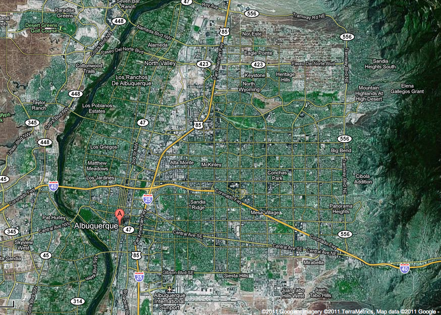
At the eastern (right) side of the photo are the Sandia mountains. The mountains make it really easy to navigate because you can always see them, and so always know which direction is east. The river west of town is the Rio Grande.
I find it interesting that people here navigate by cardinal directions much more often than people did back in New York. Instead of saying 'turn right on Paseo', you'll hear 'turn east on Paseo'.
Ollock's comments about sprawl in the US are especially applicable in Albuquerque. This city isn't all that big, as cities go (I think it's about 800,000 people), but it is _huge_, and driving across town can take forever.
I live between the words "Sandia Ridge" and "Central Ave SE", southeast of the I-25 / I-40 intersection, and have to drive to the extreme northwest and northeast parts of town for hockey practice.
Kuku-kuku kaki kakak kakekku kaku kaku.
'the toenails of my grandfather's elder brother are stiff'
'the toenails of my grandfather's elder brother are stiff'
-
HandsomeRob

- Lebom
- Posts: 76
- Joined: Tue Jan 10, 2006 9:54 am
- Location: Wisconsin
- Contact:
Re: City layouts
Here's the street layout for Norrilund as it stands now:

Note that I still have to add a bunch of streets, especially in the orange district along the river in the northeast and the pink district in the north center, but you can get a sense of how the streets are laid out. I've tried to go for a mix of tidy grid-like neighborhoods (representing newer construction and areas that have been demolished and rebuilt) and twisted, knotty networks of alleys (representing the very oldest parts of town). The fringes of the city, especially in the brown and purple districts in the southeast, you can see a newer variety of construction featuring short dead-end streets branching from main thoroughfares.
-Rob
Re: City layouts
I don't understand how it can be easy to find your way around in a grid city. Every road looks the same...
I know I'm better at finding my way by the shape of the road, like whether it goes uphill or downhill or twists left or right or east or north or what, than by counting how many intersections you go through, or however you grid people remember routes.
I know I'm better at finding my way by the shape of the road, like whether it goes uphill or downhill or twists left or right or east or north or what, than by counting how many intersections you go through, or however you grid people remember routes.
-
Latinist13
- Sanci

- Posts: 54
- Joined: Mon Jul 11, 2011 10:31 pm
- Location: Midwestern USA
Re: City layouts
We count intersections, but it gets confusing when people add in cul de sacs and developments (aka "when the city fathers got drunk" as my mother and father would say) and start naming streets after various people who you might have no clue who they are or when you get the occasional road that isn't exactly straight and is not parallel with other roads. So we also take into consideration major landmarks, such as skyscrapers, parks, major restaurants, et cetera, and we also organize towns into different districts, formally or informally.Astraios wrote:I don't understand how it can be easy to find your way around in a grid city. Every road looks the same...
I know I'm better at finding my way by the shape of the road, like whether it goes uphill or downhill or twists left or right or east or north or what, than by counting how many intersections you go through, or however you grid people remember routes.
Thus, we might say something like, "Oh, Mr. Smith? He lives in the old Terra Nova development, between 3rd Street N and Main Ave and 6th Ave E and 12th Ave E. To get to his place, you go 12 blocks north of St John's Cathedral and hook a right and go straight for another three blocks and then you reach his place," when somebody asks us for directions.
Re: City layouts
That's just weird. I'd probably lose count.Latinist13 wrote:Thus, we might say something like, "Oh, Mr. Smith? He lives in the old Terra Nova development, between 3rd Street N and Main Ave and 6th Ave E and 12th Ave E. To get to his place, you go 12 blocks north of St John's Cathedral and hook a right and go straight for another three blocks and then you reach his place," when somebody asks us for directions.
Okay, landmarks, fine. But still, howwww can it be confusing when streets have real names or a little bend that make them stand out more from the others? xDLatinist13 wrote:We count intersections, but it gets confusing when people add in cul de sacs and developments (aka "when the city fathers got drunk" as my mother and father would say) and start naming streets after various people who you might have no clue who they are or when you get the occasional road that isn't exactly straight and is not parallel with other roads. So we also take into consideration major landmarks, such as skyscrapers, parks, major restaurants, et cetera, and we also organize towns into different districts, formally or informally.

Re: City layouts
What difference does a bend make? If you're walking from Alpha Street to Kappa Street, and Delta Street curves sharply to the left if you go down it for half a mile, that does you no good, because you're just going to walk right past it and not see the bend. And even if you did, it would still be called "Kappa Street," not "the street with the little bend in it," so why not just remember the name instead of the bend? If I were giving directions in a twisty town I would still use the same terminology: "Go down X street to Y street. Go left on Y street to Z street. Go right on Z street to etc..." Unique features of the streets are irrelevant. A grid, on the other hand, would make it much easier.Astraios wrote:But still, howwww can it be confusing when streets have real names or a little bend that make them stand out more from the others? xD
[quote="Nortaneous"]Is South Africa better off now than it was a few decades ago?[/quote]
-
Latinist13
- Sanci
- Posts: 54
- Joined: Mon Jul 11, 2011 10:31 pm
- Location: Midwestern USA
Re: City layouts
*notes where Astraios is from* *Notes where self is from* I guess it depends on what you get used too. I'm used to numbered streets and a grid setup since my hometown of Fargo (Centralia) is <140 years old. Since your hometown of Manchester (Mamucium) is at least 2100 years old, I guess that can explain things...kinda. Since your town was a Roman military settlement at one point, I'd think that would lend itself to be more gridlike, but 2100 years can do a lot to roads and buildings.Astraios wrote:That's just weird. I'd probably lose count.Latinist13 wrote:Thus, we might say something like, "Oh, Mr. Smith? He lives in the old Terra Nova development, between 3rd Street N and Main Ave and 6th Ave E and 12th Ave E. To get to his place, you go 12 blocks north of St John's Cathedral and hook a right and go straight for another three blocks and then you reach his place," when somebody asks us for directions.
Okay, landmarks, fine. But still, howwww can it be confusing when streets have real names or a little bend that make them stand out more from the others? xDLatinist13 wrote:We count intersections, but it gets confusing when people add in cul de sacs and developments (aka "when the city fathers got drunk" as my mother and father would say) and start naming streets after various people who you might have no clue who they are or when you get the occasional road that isn't exactly straight and is not parallel with other roads. So we also take into consideration major landmarks, such as skyscrapers, parks, major restaurants, et cetera, and we also organize towns into different districts, formally or informally.
We sometimes simplify things by saying, "Go five blocks, turn left and go twelve blocks, then turn right and go three blocks."
Re: City layouts
That wasn't so difficult in Braunschweig either, and I hope WeepingElf (should he read this) agrees. Those ring roads are pretty convenient.Matt wrote:I like living in Albuquerque because it's so easy to find my way around.
Re: City layouts
Not see the bend even if it's a sharp one? What kind of sharp bend are you talking about?brandrinn wrote:What difference does a bend make? If you're walking from Alpha Street to Kappa Street, and Delta Street curves sharply to the left if you go down it for half a mile, that does you no good, because you're just going to walk right past it and not see the bend. And even if you did, it would still be called "Kappa Street," not "the street with the little bend in it," so why not just remember the name instead of the bend? If I were giving directions in a twisty town I would still use the same terminology: "Go down X street to Y street. Go left on Y street to Z street. Go right on Z street to etc..." Unique features of the streets are irrelevant. A grid, on the other hand, would make it much easier.

Re: City layouts
I love ring roads as well! Beijing has that layout as well, with there being a 2nd Ring Road, 3rd Ring Road, 4th Ring Road, 5th Ring Road, and I believe they are working on a 6th.Guitarplayer wrote:That wasn't so difficult in Braunschweig either, and I hope WeepingElf (should he read this) agrees. Those ring roads are pretty convenient.Matt wrote:I like living in Albuquerque because it's so easy to find my way around.
Cape Town seems to be similar to Albuquerue in that you can always see Table Mountain, no matter where you are (or at the very least, Lion's Head). If we are strictly talking about the city center, then that is on the NWern side of the mountain, so you always know which direction you are going. Including suburbs, Table Mountain actually sits right in the middle of the metro area, so it would depend on where you were relative to the mountain. The city itself is basically a grid system.
Rochester is also a grid system, with a river running through it. In fact, HandsomeRob's map looks suspiciously similar to Rochester (though not exactly the same)
-
WeepingElf

- Smeric

- Posts: 1630
- Joined: Wed Mar 08, 2006 5:00 pm
- Location: Braunschweig, Germany
- Contact:
Re: City layouts
Yes.Guitarplayer wrote:That wasn't so difficult in Braunschweig either, and I hope WeepingElf (should he read this) agrees. Those ring roads are pretty convenient.Matt wrote:I like living in Albuquerque because it's so easy to find my way around.
...brought to you by the Weeping Elf
Tha cvastam émi cvastam santham amal phelsa. -- Friedrich Schiller
ESTAR-3SG:P human-OBJ only human-OBJ true-OBJ REL-LOC play-3SG:A
Tha cvastam émi cvastam santham amal phelsa. -- Friedrich Schiller
ESTAR-3SG:P human-OBJ only human-OBJ true-OBJ REL-LOC play-3SG:A

Re: City layouts
I think Finlay pretty much covered Edinburgh. I'd just say that I've always found it quite easy to navigate in it, at least in the center and south of it - you can pretty much always see the castle, or Corstorphine Hill, or the Pentlands, or the sea, or Arthur's Seat, or Calton Hill, or that big chimney-like thingy near Haymarket. Most of the time, you can see all at once, so it's easy to triangulate your position. Plus the incessant hills/slopes help orientation immensely.
Ljubljana is also quite easy to navigate in IMO - at least on the main roads. Once you get into the side streets though... even though they're grid-like, they're often cul-de-sac-ed at the end, which may make it impossible to "drive through" residential areas in order to get onto a parallel main road. Nothing wrong with that, of course, since it keeps traffic off the side streets, but it does make you need a map if you're in an unfamiliar area. General orientation is easy though - we have a castle hill and two other large forested hills pretty much in the center (arranged in a diagonal line with a gap where the city center is in the middle), as well as easily recognizable hills/mountains to the north and the south, so it's not a problem.
In terms of "city design", there's an old town center (mostly rebuilt in baroque style following an earthquake in the 16th century I think?) with narrow streets, but it's tiny and closed to traffic. This is surrounded by a Secession/Art Noveau "greater center", organized in a semi-regular grid (this is inside the "inner ring" which is currently nearing completion - just one more bridge needs to be finished). Further afield, it's mostly a mix of large-scale industrial estates (some now turned into shopping malls), Socialist-era apartment-block-neighborhoods, and mixed residential areas (with single family homes, but can also have houses with 4-8 apartments, etc.). They're all planned out rather nicely, except in much of south Ljubljana, where many neighborhoods don't even have sidewalks (plus it's all built on a marsh, so you need to have pylons to stabilize your house, and your basement is always at risk of flooding).
High Eolic (PDF)
-
Salmoneus

- Sanno

- Posts: 3197
- Joined: Thu Jan 15, 2004 5:00 pm
- Location: One of the dark places of the world
Re: City layouts
In my experience, grids are hopelessly impossible to get to places in, because it's like walking in a hall of mirrors: everything's the same, so you don't know where you are. Until recently I was living in a little gridded area, and my housemates and I continually walked down the wrong roads, even though there were only about three options. You're always thinking "right, it's the third road on the... how many roads have I passed, is this the second or the third, or... oh, right! I came in at a different point so it was only meant to be the second and now I'm on the wrong road..."
Whereas for my other London houses I thought "past the school, turn left through the courtyard, and pick the row that faces the green space", or "where the roads come together in a sharp angle, perpendicular to that, not the narrow one coming off at 90 degrees, but the widish one at a slight angle that curves back up the hill", or "turn at the big black pub and head to the hospital, opposite the traffic lights".
However, grids are wonderful for getting OUT of if you don't know where you are, because you can use a sense of direction more easily.
----
Most of London is easy to navigate by instinct and landmarks, except for the more griddy parts, where I often find myself going to far or not going far enough or getting turned around underground and coming up pointing the wrong way. The City, however, I find a nightmare. You'd think the towers would tell you where you were, but they don't, because, because none of the roads are straight, when you're actually there you can't see even the most notable landmark until you're actually on top of it. You sort of wander around a bit and then come out of an alleyway and discover you're next to the tallest building in the city and go 'ahah! SEE? I DID know where I was!".
Blog: [url]http://vacuouswastrel.wordpress.com/[/url]
But the river tripped on her by and by, lapping
as though her heart was brook: Why, why, why! Weh, O weh
I'se so silly to be flowing but I no canna stay!
But the river tripped on her by and by, lapping
as though her heart was brook: Why, why, why! Weh, O weh
I'se so silly to be flowing but I no canna stay!

Re: City layouts
I find that the grid system works really well with consistently numbered streets. In Edmonton, we don't count intersections or blocks as much as give street numbers and landmarks. The system is set up such that
(1) a street always runs north-south
(2) an avenue always runs east-west
(3) street numbers increase going west
(4) avenue numbers increase going north.
* Edited after I mixed up the directions of (3) and (4).
So if I was giving someone instructions on how to go from my house to my friend the university, I would say:
(1) "Head east, take the first right,
(2) turn right on 23rd,
(3) and right on 111.
(4) Then turn left when the road ends at a T intersection
(5) and continue on that road till you see the signs."
Note that, as in the example above, I wouldn't even bother to mention whether a road was a street or avenue since it would be obvious from context. After heading east and turning right, the driver is going south and so must be on a street. The next turn would be an avenue, then a street, and so forth on so on.
If I'm the driver and I get to 23rd (since that's the first major road, everything before that is short and simple, i.e. you can literally see 23rd after step (1)), I know I'm heading west on an avenue, and that I'll be intersecting with increasing streets. At the first intersection I see a sign saying "34 ST", so I know I'm a long way off from my next turn and I sigh and relax. The next major street says "50 ST", then "66 ST", then "91 ST", then "99 ST", then "104ST". Now I start paying attention and make sure I'm in the right lane for a turn. Sure enough, the next set of lights brings to "109 ST", and after that, 111, where I take a right. The process repeats itself.
Two things can cause confusion. First, there's always some planner that thinks it would be cute to name a road in honour of somebody or by the name of the neighbourhood it's in. In between 34th and 50th, for example, there's "MILL WOODS RD", and between 99 and 104 there's Calgary Trail and Gateway Boulevard. Psh. Even worse, there's an entire community they designed that not only deviates from the grid, with nothing but cul-de-sac after cul-de-sac, but also has all the streets named with words beginning with J. So you end up stuck in Johnson Boulevard when you're looking for Jonson Way and it's hell.
Second, there's always some gap between streets, e.g. you pass 50 and then the next intersection, major or minor, is 53 or something, because 51 and 52 end before intersecting with 23rd, for example. If you're counting on following a certain road until you reach some far-off number, you can end up missing it this way. On the whole, however, the system is useful. I remember being surprised when visiting some other city, in Greater Vancouver (Langley?), I saw a bunch of streets intersecting streets, avenues intersecting avenues, and thinking "Wtf? What's the difference between an avenue and a street, then?" Up to then I thought the north-south/east-west distinction was universal, since it's also used in the other city I see a lot of, Calgary.
Anywhom, end of long post.
Last edited by Sevly on Sun Sep 25, 2011 8:37 pm, edited 1 time in total.
Re: City layouts
As a European used to navigate cities by landmarks and proper street names, I'd probably be like "Eh?" if I were in that situation.Sevly wrote:(1) "Head east, take the first right,
(2) turn right on 23rd,
(3) and right on 111.
(4) Then turn left when the road ends at a T intersection
(5) and continue on that road till you see the signs."
-
the duke of nuke

- Avisaru
- Posts: 467
- Joined: Thu Apr 06, 2006 1:23 pm
- Location: Leicestershire
- Contact:
Re: City layouts
I've spent most of my life in rural England, but I lived in San José, California, for two years and I can attest to the "house of mirrors" thing. It all looked very much the same, except in the very centre of the city. I also find Continental cities - especially French - occasionally puzzling because the streets very often seem to be named after dates.
My nearest city is Winchester, which is pretty easy to navigate. (Downhill goes to the city centre from almost everywhere.) The streets are mostly pretty narrow, though, since the road layout is mediaeval... it's very definitely centred around the High Street.
My nearest city is Winchester, which is pretty easy to navigate. (Downhill goes to the city centre from almost everywhere.) The streets are mostly pretty narrow, though, since the road layout is mediaeval... it's very definitely centred around the High Street.
XinuX wrote:I learned this language, but then I sneezed and now am in prison for high treason. 0/10 would not speak again.